Before the promulgation of the 2015 constitution (2072BS), Nepal had 14 zones, 75 districts, and 5 development zones. On April 13, 1961 (1st Baisakh 2018), Nepal was divided into 14 zones and 75 districts.
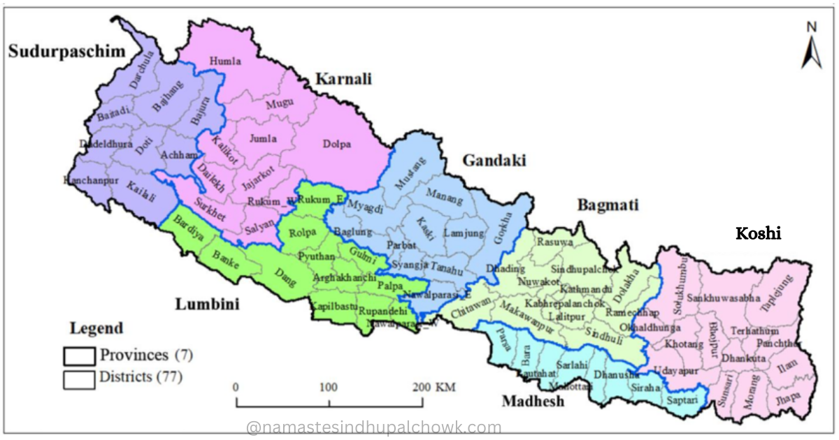
After establishing the republican system, the second Constituent Assembly declared the new constitution on September 20, 2015 (3 Aswin 2072). The new constitution transformed Nepal into a federal country. It actively formed 7 provinces by abolishing regional and development areas. The new constitution specified 77 districts within Nepal.
During a Council of Ministers meeting on August 21, 2015 (5 Bhadra 2074), they decided to split Nawalparasi and Rukum. The Council of Ministers actively divided Nawalparasi (Bardaghat Susta East) into Gandaki Province. And, Nawalparasi (Bardaghat Susta West) into Lumbini Province. Similarly, they divided the eastern part of Rukum district into Lumbini Province and the western part of Rukum into Karnali Province.
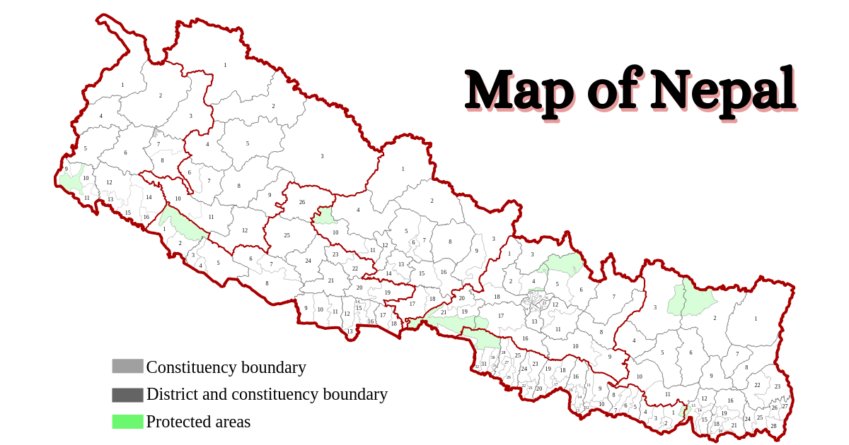
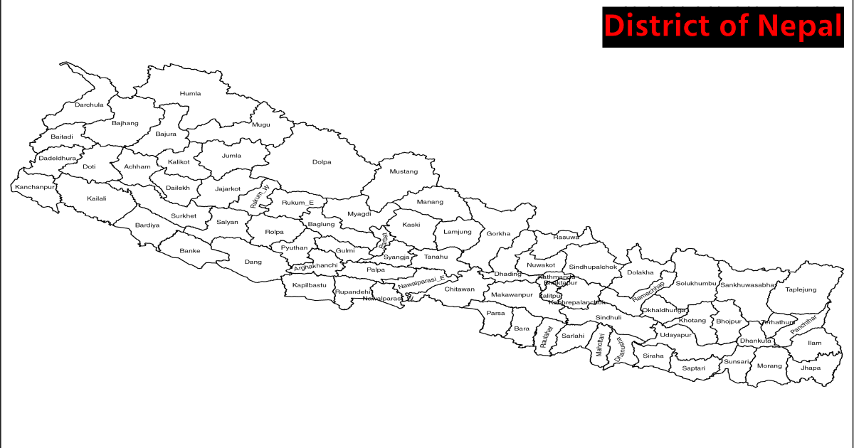
Districts of Nepal
Nepal has 77 districts. Each district has its own characteristics, traditions, and beauty. The districts differ in size, population, topography, and conditions. Some are lowlands with fertile plains, while others are hilly or mountainous.
These diverse features create various landscapes, climates, and resources. Each district divides into smaller units called local levels. And, These units govern and provide services to the people every day.
Districts in Nepal also have cultural and historical importance. They have ancient temples, palaces, and monuments that reflect the country's history and traditions. furthermore, Some districts are famous for religious sites like Muktinath and Pashupatinath.
Additionally, the districts offer stunning natural landscapes and access to trekking and mountaineering destinations. The Solu Khumbu district is home to Mount Everest, the world's highest peak, attracting adventurers worldwide. Similarly, The Annapurna region in the Kaski district is a popular trekking destination known for its breathtaking mountain views and diverse flora and fauna.
Moreover, districts in Nepal play a vital role in the country's political landscape. Each district elects representatives to the federal parliament, ensuring a democratic system of governance at the national level.
Dolpa is the biggest district of Nepal occupying 7889 square kilometres area. Similarly, Bhaktapur is Nepal's smallest district, occupying 119 square kilometres. Nawalparasi & Rukum is divided into two parts. And, create two new districts in Nepal. Rukum East (Rukum Kot) is the youngest district of Nepal.
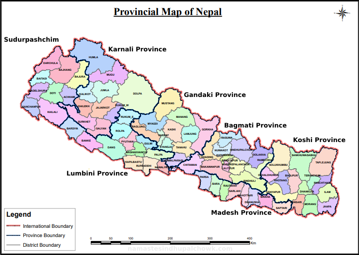
Province of Nepal
In 2015 AD, Nepal introduced the province system as part of its new federal structure. Before federalism, Nepal was divided into 14 administrative zones. However, with the new constitution, the country was restructured into seven provinces.
A province in Nepal is a subnational administrative unit that holds certain political, legislative, and executive powers. Each province has its own provincial government, led by a Chief Minister, and a provincial assembly that creates laws and policies within its jurisdiction.
The provinces in Nepal not only have geographical definitions but also aim to accommodate diverse ethnic, linguistic, and cultural identities within the country. The provincial boundaries were determined through extensive consultations, taking into account factors such as population, geography, administrative convenience, and ethnic composition.
Read Also: Important of Tourism in Nepal
The List of Districts & Province of Nepal
If you are looking for information about the provinces and & districts of Nepal, we have provided the details of the provinces and districts, headquarters, area, and population of Nepal in this article. We have prepared this list for educational purposes.
In Schedule 4 of the Constitution of Nepal, provisions have been made about the provinces of Nepal and the districts in those provinces.
List of Province of Nepal
Karnali is the biggest province of Nepal. Its area is 27984 square kilometers. There are 10 districts in this province. Similarly, Madhesh province is the smallest province of Nepal. Its area is 9661 square kilometers. There are a total of 8 districts in Madhesh province.
Bagmati is the largest province of Nepal in terms of population. There are 6116866 population in this province which has 13 districts. Similarly, Karnali is the smallest province in terms of population.
Nepal has 7 provinces. The list of provinces of Nepal with their capital city, Total Area, No. of districts & total population are:
| S.N. | Province Name | Capital City | Total Area (Sq. KM) | Total District | Total Population (2021) |
|---|---|---|---|---|---|
| 1. | Koshi | Biratnagar | 25905 | 14 | 4961412 |
| 2. | Madesh | Janakpur | 9661 | 8 | 6114600 |
| 3. | Bagmati | Hetauda | 20300 | 13 | 6116866 |
| 4. | Gandaki | Pokhara | 21504 | 11 | 2466427 |
| 5. | Lumbini | Deukhuri | 22288 | 12 | 5122078 |
| 6. | Karnali | Birendranagar | 27984 | 10 | 1688412 |
| 7. | Sudurpaschim | Dhangadhi | 19915 | 9 | 2694783 |
| Nepal | Kathmandu | 147516 | 77 | 29164578 |
The total population is based on National Population and Housing Census 2021.
List of District of Koshi Province in Nepal: Headquarters, Area, Population
Koshi region is spread in the eastern part of Nepal. The former Mechi area is now the Koshi province. Koshi is the province with the largest number of districts in Nepal. There are 14 districts in Koshi.
Taplejung is the largest district of Koshi province. Its area is 3646 square kilometers. Similarly, the small district of this province is Tehrathum, which has an area of 679 square kilometers.
Here are the list of district of Koshi province with their headquarter, total area and total population.
| S.N. | District Name | Headquarter | Total Area (Sq.KM) | Total Population (2021) |
|---|---|---|---|---|
| 1. | Taplejung | Fungling | 3646 | 120590 |
| 2. | Terhrathum | Myanglung | 679 | 88731 |
| 3. | Panchthar | Fidim | 1241 | 172400 |
| 4. | Sankhuwasabha | Khandbari | 3480 | 158041 |
| 5. | Solukhumbu | Salleri | 3312 | 104851 |
| 6. | Bhojpur | Bhojpur | 1507 | 157923 |
| 7. | Khotang | Diktel | 1591 | 175298 |
| 8. | Ilam | Ilam | 1703 | 279534 |
| 9. | Udayapur | Gaighat | 2063 | 340721 |
| 10. | Okhaldhunga | Siddhicharan | 1074 | 139552 |
| 11. | Jhapa | Bhadrapur | 1606 | 998054 |
| 12. | Dhankuta | Dhankuta | 892 | 150599 |
| 13. | Morang | Biratnagar | 1855 | 1148156 |
| 14. | Sunsari | Inaruwa | 1257 | 926962 |
List of District of Madesh Pradesh in Nepal: Headquarter, Area, Population
Madesh province of Nepal spreads the east Terai region. Madesh is the smallest province of Nepal. There are 8 districts in Madesh. The Capital city of Madesh pradesh is Janakpur. This propvince covers 9661 square kilometers area.
Saptari is the biggest district of Madesh province. Which covers 1363 Square kilo Meters area of Nepal. Similarly, Mahottari is the smallest district of Madesh pradesh with 1002 Square kilo Meters of area.
| S.N. | District Name | Headquarter | Total Area (Sq.KM) | Total Population (2021) |
|---|---|---|---|---|
| 1. | Parsa | Birjung | 1353 | 654471 |
| 2. | Bara | Kalaiya | 1190 | 763137 |
| 3. | Rautahat | Gaur | 1126 | 813573 |
| 4. | Sarlahi | Malangwa | 1259 | 813573 |
| 5. | Mahottari | Jalleswor | 1002 | 706994 |
| 6. | Dhanusha | Janakpur | 1180 | 867747 |
| 7. | Siraha | Siraha | 1188 | 739953 |
| 8. | Saptari | Rajbiraj | 1363 | 706255 |
List of Districts of Bagmati Province in Nepal: Headquarter, Area, Population
Bagmati province spreads in the middle region of Nepal. This province covers 20300 Square Kilo Meters area. There are 13 districts in Bagmati. The Capital city of Nepal locates on this province. The capital city of Bagmati province is Hetauda.
The biggest district of Bagmati province is Sindhupalchowk. which covers 2542 Square Kilo Meters area. Bhaktapur is the smallest district of Bagmati Pradesh with 119 Square Kilo Meters area.
| S.N. | District Name | Headquarter | Total Area (Sq KM) | Total Population (2021) |
|---|---|---|---|---|
| 1. | Kathmandu | Kathmandu | 395 | 2041587 |
| 2. | Lalitpur | Lalitpur | 385 | 551667 |
| 3. | Bhaktapur | Bhaktapur | 119 | 432132 |
| 4. | Kavre | Dhulikhel | 1396 | 364039 |
| 5. | Sindhupalchowk | Chautara | 2542 | 262624 |
| 6. | Dolakha | Charikot | 2191 | 172767 |
| 7. | Dhading | Dhading Besi | 1926 | 325710 |
| 8. | Nuwakot | Bidur | 1121 | 263391 |
| 9. | Makwanpur | Hetauda | 2426 | 466073 |
| 10. | Rasuwa | Dhunche | 1544 | 46689 |
| 11. | Ramechhap | Manthali | 1546 | 170302 |
| 12. | Chitwan | Bharatpur | 2218 | 719859 |
| 13. | Sindhuli | Sindhulighadi | 2491 | 300026 |
List of District of Gandaki Province: Headquarter, Area, Population
Gandaki spreads in the western part of Nepal from Kathmandu. The second largest city of Nepal (Pokhara) lies in this province. There are 11 districts in Gandaki. The total area of Gandaki is 21504 Square kilometers.
Gorkha is the largest district of Gandaki province with 3610 Square Kilo Meters area. Similarly, Parbat is the smallest district of Gandaki province with 494 Square Kilo Meter areas.
| S.N. | District Name | Headquarter | Total Area (Sq KM) | Total Population (2021) |
|---|---|---|---|---|
| 1. | Kaski | Pokhara | 2017 | 600051 |
| 2. | Gorkha | Gorkha Bazar | 3610 | 251027 |
| 3. | Nawalparasi (Bardaghat Susta East) | Kawasoti | 1043 | 378079 |
| 4. | Parbhat | Kusma | 494 | 130887 |
| 5. | Tanahu | Damauli | 1546 | 321153 |
| 6. | Baglung | Baglung | 1784 | 249211 |
| 7. | Myagdi | Beni | 2297 | 107033 |
| 8. | Lamjung | Besisahar | 1692 | 155852 |
| 9. | Syangja | Putali Bazar | 1164 | 253024 |
| 10. | Manang | Chame | 2246 | 5658 |
| 11. | Mustang | Jomsom | 3573 | 14452 |
List of District of Lumbini Province: Headquarter, Area, Population
Lumbini is the birthplace of Lord Buddha. So, Province No. 5 is named Lumbini. This province spreads western Terai of Nepal. There are 12 districts in Lumbini Province. The capital city of Lumbini Pradesh is Deukhuri, Dang.
Dang is the largest district of Lumbini with 2955 Square Kilometers area. Similarly, Parasi is the smallest district in this province. Which covers a 634.88 Square Kilometer area. The list of districts locates in Lumbini Province are as follows with their Area, Population & Headquarter:
| S.N. | District Name | Headquarter | Total Area (Sq KM) | Total Population (2021) |
|---|---|---|---|---|
| 1. | Parasi | Parasi | 634.88 | 386868 |
| 2. | Dang | Ghorahi | 2955 | 674993 |
| 3. | Gulmi | Tamghas | 1149 | 246494 |
| 4. | Kapilvastu | Taulihawa | 1738 | 246494 |
| 5. | Arghakharchi | Sandhikharka | 1193 | 177086 |
| 6. | Palpa | Tansen | 1373 | 245027 |
| 7. | Rukum East | Rukumkot | 1161.13 | 56,786 |
| 8. | Pyuthan | Pyuthan | 1309 | 232019 |
| 9. | Banke | Nepalgunj | 2337 | 603194 |
| 10. | Bardiya | Gulariya | 2025 | 459900 |
| 11. | Rupandehi | Sidharthanagar | 1360 | 1121957 |
| 12. | Rolpa | Liwang | 1879 | 234793 |
List of District of Karnali Pradesh: Headquarter, Area, Population
Karnalii is the longest river in Nepal. Province No. 6 is named after the Karnali River. Karnali is the largest province of Nepal. The total area of this province is 27984 Square kilometers. Birendranagar is the capital city of Karnali province. There are 10 districts in Karnali.
Dolpa is the largest district of Karnali with 7889 Square Kilometers area. Similarly, Rukum West is the smallest district. Which covers 1213.49 Square Kilometer area. The list of districts of Karnali province are:
| S.N. | District Name | Headquarter | Total Area (Sq KM) | Total Population (2021) |
|---|---|---|---|---|
| 1. | Rukum West | Musikot | 1213.49 | 166740 |
| 2. | Mugu | Gamgadhi | 3535 | 64549 |
| 3. | Dailekh | Narayan | 1502 | 252313 |
| 4. | Dolpa | Dunai | 7889 | 42774 |
| 5. | Jumla | Chandannath | 2531 | 118349 |
| 6. | Jajarkot | Khalang | 2230 | 189360 |
| 7. | Kalikot | Manma | 1741 | 145292 |
| 8. | Salyan | Khalanga | 1462 | 238515 |
| 9. | Surkhet | Birendranagar | 2451 | 415126 |
| 10. | Humla | Simikot | 5655 | 118349 |
List of District of Sudurpachchim Pradesh: Headquarters, Area, Population
Sudurpachchim province spreads in the far western region of Nepal. This province was formed from the former Sudurpachchimachal Development Region. The total area of this province is 19915 Square kilometers. Dhangadhi is the capital city of Sudurpachchim Pradesh.
Bajhang is the largest district of Sudurpachchim Province with 3422 Square Kilometers area. Similarly, Baitadi is the smallest district of this province, which spreads over 1519 Square Kilometers area.
| S.N. | District Name | Headquarter | Total Area (Sq KM) | Total Population (2021) |
|---|---|---|---|---|
| 1. | Kailali | Dhagadhi | 3235 | 904666 |
| 2. | Kanchanpur | Mahendranagar | 1610 | 513757 |
| 3. | Achham | Mangalsen | 1680 | 228852 |
| 4. | Dadeldhura | Amargadhi | 1538 | 139602 |
| 5. | Doti | Dipayal | 2025 | 204831 |
| 6. | Darchula | Darchula | 2322 | 133310 |
| 7. | Bajhang | Chainpur | 3422 | 189085 |
| 8. | Bajura | Martadi | 2188 | 138523 |
| 9. | Baitadi | Dasarathchand | 1519 | 242157 |
Districts of Inner Madhesh
There are seven districts in inner Madhesh in Nepal. Inner Madhesh means that some parts are flat plains and some parts are covered by mountains. Inner Madhesh occupies 8.5% of the total area of Nepal. Similarly, 9.87% of the total population of Nepal lives in Inner Madhesh. This region is home to a hot monsoon climate. The list of district of Inner Madhesh are;
| S.N. | District Name | Headquarter |
|---|---|---|
| 1. | Udayapur | Gaighat |
| 2. | Sindhuli | Sindhuli Gadhi |
| 3. | Makawanpur | Hetauda |
| 4. | Chitwan | Bharatpur |
| 5. | Nawalpur | Kawasoti |
| 6. | Dang | Ghorahi |
| 7. | Surkhet | Birendranagar |
Top 5th Smallest District (Area Basis) of Nepal
Bhaktapur is the smallest district of Nepal, which spreads over 119 Square Kilometers area. Similarly, Lalitpur, Kathmandu, Parbat & Parasi are the top five smallest districts of Nepal respectively. The List of the top 5th smallest districts of Nepal.
| S.N. | District Name | Total Area (Sq KM) |
|---|---|---|
| 1. | Bhaktapur | 119 |
| 2. | Lalitpur | 385 |
| 3. | Kathmandu | 395 |
| 4. | Parbat | 494 |
| 5. | Parasi | 634.88 |
Top 5th Biggest District (Area Basis) of Nepal
Dolpa is the largest district of Nepal, which spreads over 7889 Square kilometers area. Humla, Taplejung, Gorkha, Mustang are the top five largest districts of Nepal respectively. The list of top 5th biggest districts of Nepal.
| S.N. | District Name | Total Area (Sq KM) |
|---|---|---|
| 1. | Dolpa | 7889 |
| 2. | Humla | 5655 |
| 3. | Taplejung | 3646 |
| 4. | Gorkha | 3610 |
| 5. | Mustang | 3573 |
Top 5th Largest Districts of Nepal Based on Population
Kathmandu is the largest district of Nepal based on Population. There are 20, 41, 587 population in Kathmandu district. Similarly, Kathmandu, Morang, Rupandehi, Jhapa, & Sunsari are the top five largest district of Nepal based on Population.
| S.N. | District Name | Population |
|---|---|---|
| 1. | Kathmandu | 20,41,587 |
| 2. | Morang | 11, 48,156 |
| 3. | Rupendehi | 11,21,957 |
| 4. | Jhapa | 9, 98,054 |
| 5. | Sunsari | 9, 26,962 |
Top 5th Smallest Districts of Nepal Based on Population
Manang is the smallest district of Nepal based on population. There are 5658 population in Nepal. Manang, Mustang, Dolpa, Rasuwa & Humla are the top five smallest district of Nepal based on population. The list are:
| S.N. | District Name | Population |
|---|---|---|
| 1. | Manang | 5,658 |
| 2. | Mustang | 14,452 |
| 3. | Dolpa | 42,774 |
| 4. | Rasuwa | 46,689 |
| 5. | Humla | 55,394 |
Map of Nepal with Province & Districts
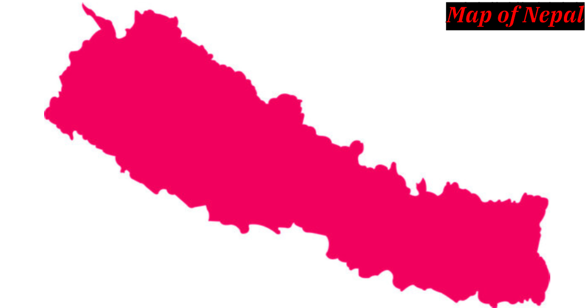
The map of Nepal extends from the Mechi River in the east to the Mahakali River in the west. Looking at the geographical location of Nepal, the average length from east to west is 885 km. Similarly, the average width from north to south is about 193 km. The total area of Nepal is 147516 square kilometres.
Local Government Operation Act-2074 and Classification of District
According to the Local Government Operation Act 2074, the districts of Nepal have been divided into five parts. According to that, the districts of Nepal have been divided into Himalayas, Hills, Terai, Inner Madhesh and Valley. According to the provision of this act, the following number of districts are classified into the following categories;
| Category | Number of District |
|---|---|
| Himal/ Mountain | 21 |
| Pahad/ Hills | 28 |
| Tarai | 18 |
| Inner Tarai | 7 |
| Upatyaka/ Valley | 3 |
Frequently Asked Question
Many people search thier queries related to province & district of Nepal. We explain this queries as a FAQs. Which are given below.
Youngest District of Nepal
| Rukum East (Rukumkot) is the youngest district of Nepal. It has 1161.13 square kilometers area. It is located in the Lumbini province of Nepal. During a Council of Ministers meeting on August 21, 2015 (5 Bhadra 2074), they decided to split the Rukum district as Rukum East & Rukum West. And, Rukum East is established as a new or young district of Nepal at 2074 Ashoj 18. |
Smallest District of Nepal
| Bhaktapur is the smallest district of Nepal. It has 119 square kilometers of area. It lies in the Bagmati province of Nepal. This district is also known as "NachGhan Ko Rajhdhani". Although the area of Bhaktapur is small, there are 432132 total population. |
Biggest District of Nepal
| Dolpa is the biggest district of Nepal. It has 7889 square kilometers area. It locates in Karnali province. Although the area of Dolpa is big, the pupulationof this district are 42774 according to National Census 2077 BS. |
When did Nepal divide into 77 districts?
| Nepal divided into 77 districts on August 21, 2015 (5 Bhadra 2074). |
Which are the districts of Nepal that touch both China and India?
| Taplejung & Darchula are the districts of Nepal that share border with both nation India and China. |
Which district of Nepal has borders with many districts?
| Sindhuli district shares its border with more district. |
Which district has the most population in Nepal?
| Kathmandu has the most population in Nepal. According to National Census 2078, there are 2,041,587 population in Kathmandu. |